

What you need to know
Newcastle- Country Map
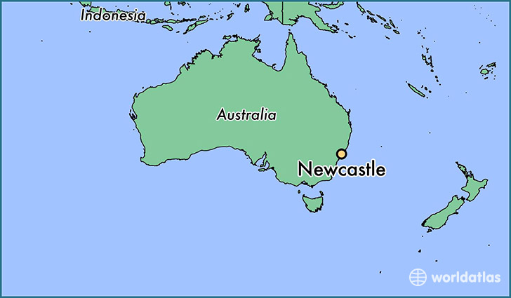
The Newcastle metropolitan area is the second most populated area in the Australian state of New South Wales and includes most of the Newcastle and Lake Macquarie local government areas. It is the hub of the Greater Newcastle area which includes most parts of the local government areas of City of Newcastle, City of Lake Macquarie, City of Cessnock, City of Maitland and Port Stephens Council.
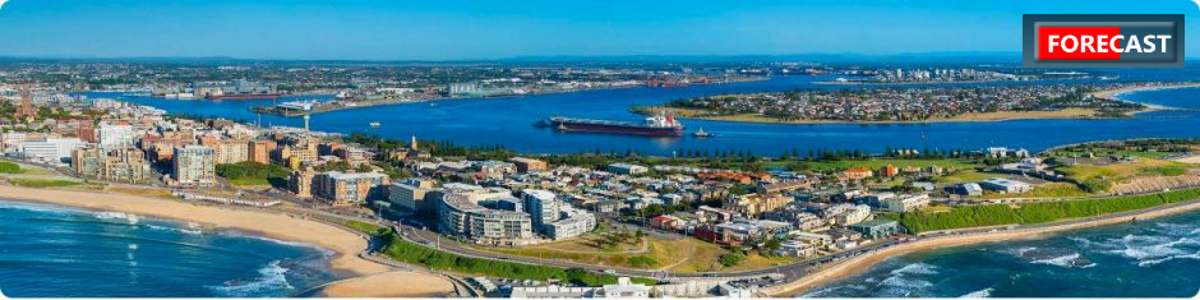
Located 162 kilometres (101 mi) north-northeast of Sydney, at the mouth of the Hunter River, it is the predominant city within the Hunter Region. Famous for its coal, Newcastle is the largest coal exporting harbour in the world, exporting 154.45 million tonnes of coal in 2013–14. Beyond the city, the Hunter Region possesses large coal deposits. Geologically, the area is located in the central-eastern part of the Sydney basin.
Population: 434,454 (2016)
Language
In Newcastle City, 8.3{ca4c843eb7e37836762fca9e99a21121ce0c2c5f8af575aaa0ff95d9f718fe24} of people spoke a language other than English.
Currency
The Australian Dollar (AUD) is the official currency of the Commonwealth of Australia.
Geography
Newcastle is on the southern bank of the Hunter River mouth. The northern side is dominated by sand dunes, swamps and multiple river channels. A “green belt” protecting plant and wildlife flanks the city from the west (Watagan mountains) around to the north where it meets the coast just north of Stockton. Urban development is mainly restricted to the hilly southern bank. The small town of Stockton sits opposite central Newcastle at the river mouth and is linked by ferry. Road access between Stockton and central Newcastle is via the Stockton Bridge, a distance of 20 km (12 mi). Much of the city is undercut by the coal measures of the Sydney sedimentary basin, and what were once numerous coal-mining villages located in the hills and valleys around the port have merged into a single urban area extending southwards to Lake Macquarie.
Climate
Newcastle has a humid subtropical climate (Cfa), typical to the Australian east coast. Summers tend to be warm and at times humid, winters are generally mild. Precipitation is heaviest in late autumn and early winter.
Education
Primary and secondary schools
The oldest state school in the area is Newcastle East Public School, a primary school established in 1816. Newcastle East Public School is the oldest continuously operating school in Australia, and will celebrate its bicentenary in 2016. Newcastle High School, which was formed by the merger of three schools, traces its lineage to a secondary school section initially founded on the grounds of Newcastle East Public School. There are three selective state schools in the area. Hunter School of the Performing Arts is a fully selective K-12 school and only takes students by audition. Merewether High School is a fully selective high school in the suburb of Broadmeadow. Hunter Sports High School is a partially selective sporting high school. The school accepts around half its students from the local area and around half by audition.
The two main independent schools in Newcastle are Newcastle Grammar School and St Philip’s Christian College, both coeducational K-12 schools.
Tertiary and further education
The city’s main provider of tertiary education is the University of Newcastle. It was established in 1951 as a satellite campus of the University of New South Wales and obtained autonomy in 1965. The University now offers over 150 undergraduate and graduate courses to a student population of more than 38,000, including 7,000 international students from more than 113 countries. The main campus is in the suburb of Callaghan about 12 km (7 mi) from the CBD.
There are three campuses of the Hunter Institute of TAFE, one located in the Newcastle CBD, one in the suburb of Hamilton East and the other located in the suburb of Tighes Hill. The Tighes Hill campus is the network’s largest campus and offers courses in business, hospitality and various trades.
Transport
Like most major cities, the Newcastle metropolitan area has an extensive system of both road links and road based public transport services (bus, taxi etc.) which cover most areas of both Newcastle and Lake Macquarie and which extend beyond the metropolitan area itself. Rail transport, however, is accessible to only a relatively small percentage of the population along the major rail transport routes and ferry services are restricted to those commuting between Newcastle and Stockton. Within the metropolitan area the car remains the dominant form of transportation. At the time of the 2001 Census, less than 4{ca4c843eb7e37836762fca9e99a21121ce0c2c5f8af575aaa0ff95d9f718fe24} of the population caught public transport, of which around 2.5{ca4c843eb7e37836762fca9e99a21121ce0c2c5f8af575aaa0ff95d9f718fe24} travelled by bus and 1{ca4c843eb7e37836762fca9e99a21121ce0c2c5f8af575aaa0ff95d9f718fe24} used the train or ferry to commute to work. On the other hand, over 72{ca4c843eb7e37836762fca9e99a21121ce0c2c5f8af575aaa0ff95d9f718fe24} of the population travelled by car to and from work. Newcastle, like all major Australian urban centres, had a tram system, but it was closed in 1950. In 2014 it was announced that trams would return to the city as a modern light rail system.
Road
Newcastle is connected to surrounding cities by the Pacific Motorway (South), Hunter Expressway (West), New England Highway (West) and the Pacific Highway (North and South). Hunter Street, the main shopping street in the Newcastle CBD, is the major link to the Pacific Highway from the CBD.
Bus
Bus services within Newcastle are operated by Newcastle Buses & Ferries, a subsidiary of the State Transit Authority. Trips within a designated area of the Newcastle CBD on State Transit-operated bus services are fare-free under the Newcastle Alliance’s Free City Buses programme. Hunter Valley Buses, Port Stephens Coaches and Rover Coaches also operate services into the CBD from other parts of the Hunter Region.
The network radiates from a bus terminal near Newcastle railway station, on the waterfront of Newcastle’s CBD. Major interchanges are located at the University of Newcastle, Wallsend, Glendale, Warners Bay, Belmont, Charlestown Square, Westfield Kotara and Broadmeadow station.
Greyhound Australia, Premier Motor Service and Sid Fogg’s long distance services serve Newcastle.
Rail
The Newcastle area is serviced by two NSW TrainLink intercity lines providing local and regional commuter services from Hamilton after the closure of the Newcastle line. The Central Coast & Newcastle Line has twice-hourly train services to Sydney and the Central Coast. The Hunter Line has twice-hourly services to Maitland and less frequently to Scone and Dungog. Two long distance lines operate through the Newcastle area using Broadmeadow station. These provide services to Moree, Armidale, Brisbane and Sydney.
Newcastle once had rail passenger services to Belmont and Toronto, on Lake Macquarie, Wallsend, Kurri Kurri and several towns and villages between Maitland and Cessnock on the South Maitland Railway, but these lines have been closed. In the late-1990s there was intense debate about the future of the rail line into central Newcastle. The New South Wales government had planned to cut the line at Broadmeadow station, ending rail services into Newcastle station in the city centre to allow better connections between the city and the waterfront precinct. This proposal was dropped in 2006.
The proposal to close the line was reactivated and in December 2014, the Newcastle line was curtailed to Hamilton. A new Wickham Transport Interchange will be built from where the Newcastle Light Rail line will operate.
From 1924 until 1994, Broadmeadow Locomotive Depot was the main railway centre for the Hunter region. Cardiff Locomotive Workshops opened in 1928, primarily as a major repair centre for New South Wales Government Railways locomotives, although it did build twelve 38 class and two 58 class locomotives. Today it is operated by Downer Rail and along with UGL Rail’s Broadmeadow plant, remains active as a locomotive and rolling stock manufacturer and repairer.
Water
The Port of Newcastle is crucial to the economic life of Newcastle and the Hunter Valley region beyond. Over 90 million tonnes of coal is shipped through the facility each year – making it the largest coal exporting port in the world. The Port of Newcastle claims to be Australia’s first port. Coal was first exported from the harbour in 1799.
Newcastle Buses & Ferries operates a ferry service across the Hunter River between Newcastle’s CBD and Stockton.
Air
Newcastle Airport is located 15 km (9 mi) north of the Newcastle CBD (27 km (17 mi) by road). The airport, which is a joint venture between Newcastle City Council and Port Stephens Council, has experienced rapid growth since 2000 as a result of an increase in low cost airline operations. The airport is located at RAAF Base Williamtown, a Royal Australian Air Force base on land leased from the Department of Defence.
Newcastle Heliport operates alongside the lower section of Newcastle Harbour.
The suburb of Broadmeadow is home to the base of the Westpac Life Saver Rescue Helicopter Service. The Helicopter service is one of the longest running services of this type in the world. Two helicopters operate out of this base and operate 24 hours a day.
The closure of Belmont Airport, commonly referred to as Aeropelican, in the Lake Macquarie suburb of Marks Point has caused Williamtown to become Newcastle’s only major airport and residents in the south of the Newcastle metropolitan area must commute up to 55 km (34 mi) by car to reach Williamtown.
Public Transport
![]()
Newcastle offers a range of public transport services, including buses, the Stockton Ferry and trains.
The NSW Government has primary responsibility for public transport planning and service provision.
Council’s role in public transport is primarily one of facilitation through:
- Supportive land use and development decisions
- Consulting with transport providers and advocating network improvements
- Provision of infrastructure such as shelters and seating, and good walking connections to public transport nodes
- Supporting other levels of government to promote public transport use
- Parking management.
To plan your trip using public transport, go to the trip planner at transportnsw.info. You can also use this site to access comprehensive information about fares and tickets, maps, timetables, service changes and using public transport.